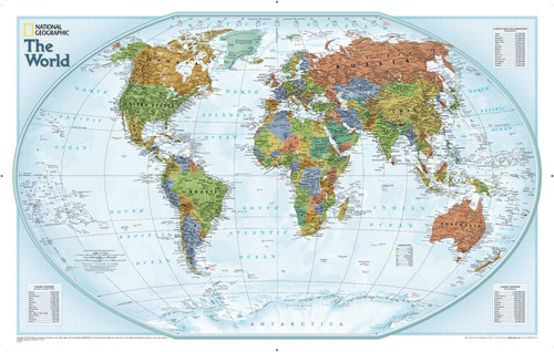
The perfect map for your classroom or office. Bright colours and rich detail bring the world alive in this World Explorer map. Enjoy the accuracy and beauty of this world map with a vibrant colour palette that fills each country for easy identification. Test your students' knowledge with corner insets featuring the largest cities by population and the largest countries by land mass and population. Time zones are also included, making this map ideal for a wide range of educational or global business activities.
This map uses a bright, easy to read color palette featuring muted oceans and stunning shaded relief that makes political boundaries come alive. Drawn in the Winkel Tripel projection, distortions of land masses around the poles are minimized: unlike many other World maps, Greenland is accurately shown as the same size as Argentina and not the size of all of South America.
Thousands of place names are carefully placed on the map to maintain legibility even in the heavily populated areas of Europe, Asia and the Middle East. Details include clearly defined international boundaries, cities, physical features, rivers, and ocean floor features.
National Geographic's maps are the standard by which all other reference maps are measured. They are meticulously researched and adhere to National Geographic's convention of making independent, apolitical decisions based on extensive research using multiple authoritative source.
Printed on polypropylene, an ideal material for wall maps as the printing brings out rich colours, and crisp edges for readability. The material is stronger than most papers and unlikely to crease or rip. The matte finish eliminates glare, and adds texture to the map. Ideal for display.
Your map is rolled and packaged in a sturdy tube to protect it during shipment.